Before I talk about my tale I think it’s necessary to talk a bit about the Drakensberg since it is not only majestic and a must see, but it is also one of South Africa’s eight World Heritage Sites. I’ll keep it short:
The name Drakensberg is Afrikaans for “Dragon Mountain” and they are the highest mountains in South Africa. The "Berg" as it is often referred to, consists of a high 180km long escarpment, in-cut by deep valleys that run easterly toward the Indian Ocean. In-between these valleys, peaks rising to 3300m are found. To the west of the escarpment lie large rolling mountains inhabited mostly by Bashoto herdsmen who live an almost hunter gatherer lifestyle. The Drakensberg also boasts, collectively 40,000 works of Bushmen art scattered throughout the many caves making it the largest of such work in the world. Basically, GO SEE IT or even better GO HIKE IT!!
So, let’s begin (you might need a coffee): I never thought it was possible to die of hypothermia in South Africa. I suppose learning first hand is the best way to find out and to NEVER FORGET!! It also kind of reminds you that South Africa is REALLY not for sissies. Without a question of doubt, this posting goes out to my fearless, and “much more fit than me” hiking companions – Isabelle, Richard, and Aidan. Thanks guys – I wouldn’t have wanted to almost die of hypothermia with any others!!
As I write about my adventures I slowly start to realize that marked paths aren’t my thing. I always seem to get lost. The good thing I suppose is that I’m never alone when it happens so it can’t really just be me…can it?
The plan for the weekend was fun and simple: head to the Drakensberg area to do some hiking and mountain biking. Drive out late on Friday after work, start hiking early Saturday morning, chill Saturday night, MTB on Sunday and then make the trek back home.
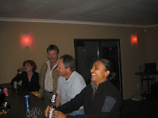
The trip started off “almost” as planned. With leaving after work and trying to escape the office we actually ended up leaving a little bit later than we had hoped, but we still arrived at the Amphitheatre Backpackers Youth Hostel, where we were staying, early enough to have a drink and get a good night’s rest.
The next morning was amazing. Breathtaking scenery and fresh air – a good escape from the daily city commute!! We had a hearty breakfast and spent a couple of minutes debating whether we wanted to take a packed lunch from the hostel or not since it didn’t sound too appetizing. Little did we know that taking the lunch was probably our smartest decision for the day. We put on our light summer hiking clothes, got our lunches, packed our day packs, and headed off in the car to where we had planned to go hiking.
 When we got to the park entrance, the guy handed us a paper showing four or five different hikes. We paid him the entrance fee and carried on, while studying the map on the way to the car park we decided to take the one that heads to an area called Neptune’s Pool. The hike was about 8km return and a slight workout, but nothing too hectic. The plan was to just enjoy the day and the scenery to make it back at a decent time to enjoy a few drinks, dinner, and then rest up for a day of biking on Sunday.
Little did we know that the map of the four or five different hikes were the only ones we were allowed to take without having a guide accompany us. Regardless, or more like oblivious, we were on our way. It took us a while to find the path, which I suppose should have been an indication as to how the day was going to turn out.

When the hike first started we were confident that we were on track as the path we were on seemed well traveled. Whenever we were unsure of what direction to turn we found a sign. Most were decrepit and buried in shrubbery, but at least we were able to find them.

The paths are nothing like we have back home in Canada and from what Aidan tells me, in Australia. Back home if there’s a trail it’s well marked and well traveled. Little did we know that that was not the case in SA. However, the day was beautiful and we were enjoying it and each other’s company so, despite the questionable paths that kept forming in front of us, we kept trekking along looking for that conveniently placed sign to let us know we were on the right path.


There was a point where we even ran out of path and ended up at a stream. We stopped and decided to cross it as there was really no other alternative other than to turn back. We took off our shoes and socks and hopped across a few rocks, tread through a bit of stream, dried our feet, rebooted and we on our way again, looking for the next conveniently placed sign to appear just as we’d lost hope and were about to turn back.


It wasn’t too long after lunch when our hike started to take a turn. About 20 minutes of hiking along after lunch we actually ran out of path and encountered nothing but water and steep cliffs with sporadic shrubbery. Richard actually scaled part of the cliff to see if there was an alternate route.


Unfortunately it looked like we could go no further so we turned around and headed back in the direction we came.

We arrived back to a clearing about 30 minutes later. It was around 13:00 and we weren’t quite ready to head back to the car and end our day of hiking in the mountains. We came to a sign that had a few marked paths and decided that the one called Contour Path would be a good one to start on. It wasn’t on our map, but not knowing that we required a guide for the path or even how long the path was, we set off with the thought in our minds, well mine anyways, that we could always turn back if we needed to.

So off we set for the contour path. It was a bit tougher than Neptune’s Pool and me being in the shape I was in struggled through some bits, but was loving every second of it.

After about an hour of some insane paths (ie. non-existent ones) my lack of fitness was starting to kick in and I was struggling, but nonetheless forging ahead.

At the time I’m sure it didn’t seem like I was enjoying myself as I would occasionally stop to blurt out to the fit bunch "are you f***ing kidding me?” But ahead we forged and as it was starting to get late, we also intensified the pace.

We hiked until we had about two hours of daylight left when we started to seriously question where we were and how much further we had to go. We had Richard who was looking at a map we were no longer on and Aidan with his GPS saying “we are here and we need to be there, but I’m not sure what’s in between.”

It was at this very moment when I managed to find cell phone reception at a clearing we reached and I decided to call my friend Liani. Her and her friend Maria had hiked the entire Drakensberg range a few years back and for some reason I recalled it taking them quite some time.
Liani informed me that it took them 9 days to hike the trail we were on with a guide and asked me why I was asking. Right when I told her we were lost, as luck of the day would have it, I lost my cell phone reception leaving Liani in a mode of panic. I didn't really know what to do at that very moment so I wrote an sms saying we were going to find a place to sleep for the night and sent it to her hoping she would get it as we hiked along and got to an area with reception.
We managed to find an area where we scaled down to a river. As much as I wanted to turn back I knew that we wouldn't make it off the mountain before dark and so we decided to forge ahead in hopes that we could find an out. We walked in rapid rivers waste high for a few kilometers, with no time to take socks or shoes off. After about an hour we decided it would probably be best to find a place to settle for the night and found a leaky covered area (I would call it a cave, but it was far from that) to sleep in. We spent the last hour of daylight finding leaves to make it a bit softer and drier and filled up our water bottles with the fresh river water to settle in for the night.


It was a long night with Richard shaking like a leaf, rocks under Aidan's hip and back no matter which way he turned, water dripping on Isabelle and I (Isabelle had it worse), and all of us soaked to the bone from walking in the river. We had half a granola bar and some wine gums for dinner and saved our apples for breakfast.
Aidan and I started discussing the various noises we were hearing which did not make me feel all warm and fuzzy inside, but we soon realized it was Richard's snoring so I suppose some of us got some sleep!! We woke at the first sign of daylight, filled up the water bottles, had our apple, put on our soggy socks and shoes, and started heading down the river hoping there was a clearing and no waterfall at the end.
It was a bit stressful and nerve-wrecking with Richard's knees giving way and the intensity of the rapids we were walking through and the cliffs to each side. After what seemed like forever (I think it was about 5km in the rapids) we were led into a clearing and back onto a path that would lead us back to the start of our outing. Good thing too because they were about 30 minutes from sending out a search party. As soon as we reached the opening the sun came out and it ended up being another amazing day!!

Needless to say we were lucky!! When we got back we found out that a lot of people actually get lost in the Drakensberg and some never even make it out. I definitely have to give thanks to Liani and Maria for all the concern and efforts to find out where we were to send help our way and sorry for the worry I put you guys through.
This is a map of the route we ended up completing when all was said and done. It’s a bit hard to see, but it’s the path in red that Aidan downloaded from his GPS. At the bottom of the picture, where it goes from grey to green is where we managed to scale down the side of the mountain and spent the night in our cave before hiking out along (and by along I mean through) the river.
 Looking back it was one of the most memorable and best weekends I’ve had in SA. Being with Aidan, Richard, and Isabelle made all the difference. Everyone always stayed in good spirits and just enjoyed every minute of it, joking around and enjoying the scenery. What an amazing bunch of friends. THANKS GUYS!!
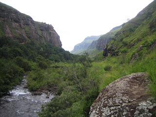
As I mentioned earlier, once we reached an opening, with no more rivers to walk through and no more cliffs on each side the worry disappeared, the clouds cleared, the sun came out and the scenery was just as stunning as the minute we arrived. I’ve included pictures of some of what we passed along the way.


 This last one could be debated as being scenery or not, but I thought I would end this tale with the state of Aidan’s pants by the end of it all. I know we went through a lot and roughed it a bit, traveling through the rivers, sleeping on leaves on the ground, but again, I’m not so sure how Aidan got so dirty…
 The End!!